5.1 Burn Area and Perimeter
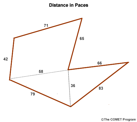
5.1 Burn Area and Perimeter Anonymous (not verified)The perimeter is the distance around the fire or along the handline. Perimeter is determined by adding the lengths of the various lines that enclose the black area of a fire. Because fires often burned in unusual shapes such as fingers, the perimeter of a fire can be approximated by assembling a combination of known shapes and lines.
Area is the amount of surface covered within a given perimeter and is useful in determining burnout acreage. Area is always in square units: for example, square feet (ft2), square yards (yd2), or acres, which represents a square distance.
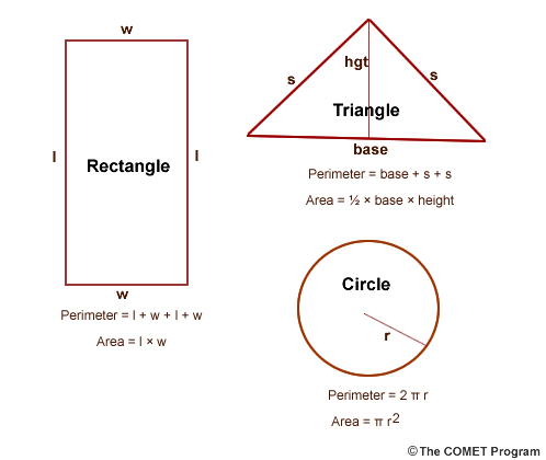
A square, rectangle, and triangle are shown in the following figures, with their formulas for area and perimeter.
Determining perimeter and burn area after a fire is often necessary. Average dimensions for a sketch can be obtained by pacing or walking around and through the burn. This method is especially useful for small fires. Global Positioning Systems (GPS) are used for larger fires to determine their shape, area, and perimeter.
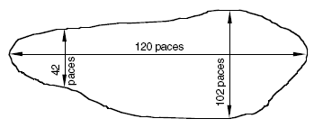
Example 1 - John sketched the following burn shape in his firefighter's notebook. Use this information to determine the acreage of the fire. John's pace is 12 paces per chain.
Step 1. Set up the cancellation table so all units will cancel, except the desired unit, chains.
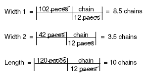
Step 2. Take the average of the two widths. The average width = 8.5 chains + 3.5 chains / 2 = 12 / 2 = 6 chains.
Step 3. Use the equation for determining the area of a rectangle.
Area of rectangle = length × average width
Area = 10 chains × 6 chains = 60 square chains.
Step 4. Set up the cancellation table so all units will cancel, except the desired unit, acres.
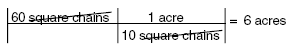
The area of the fire is 6 acres.
ACREAGE GRID
A clear acetate/plastic dot acreage grid can be placed over the mapped sketch of a burn area. It is important that the plastic grid overlay and burn map have the same scale. Burn area is determined by counting the number of dots inside the sketch of the burn. For dots that are on the border of the burn sketch, count every other dot. Multiply the number of dots counted by the dot conversion factor. This conversion factor is typically indicated on the bottom of the plastic overlay.
Example 2 - Janie sketched out a burn area in the following shape on a 7.5 minute USGS quadrangle map. The U.S. Geological Survey (USGS) produces a series of standard maps to various scales. The 7.5 minute map series has a 1:24,000 scale. One inch on a 7.5 minute map represents 2,000 feet on the ground. (See Chapter 6, Latitude and Longitude, for more information.) Use the acreage grid overlay to determine the area of the fire.
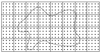
Step 1. Count the number of dots within the shape. Count every other dot for dots on the borderline. There are 181 dots.
Step 2. Read the overlay scale to obtain the dot-grid conversion. In this case the conversion is 2.500 acres per dot.
Step 3. Set up the cancellation table so all units will cancel, except the desired unit, acres.
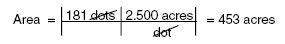
The area of the above figure is about 453 acres.