6.0 Location - Introduction
6.0 Location - Introduction Anonymous (not verified)Chapter 6 provides information on finding your current location by using bearing, azimuth, back azimuths, a compass, and a map. It describes techniques for correcting for declination and explains intersection, resection, latitude, and longitude. Additional information highlights Global Positioning Systems (GPS), base, townships, range, and sections.
6.1 Bearing
6.1 Bearing Anonymous (not verified)A bearing provides a direction given as the primary compass direction (north or south), degree of angle, and an east or west designation. A bearing describes a line as heading north or south, and deflected some number of degrees toward the east or west. A bearing, therefore, will always have an angle less than 90°.
Example 1 - Megan starts at a point and goes in the direction shown in the figure below. What is her bearing?
Megan is in the NE quadrant. The primary compass direction is north. Count the degrees down from North, for a total of 70°.
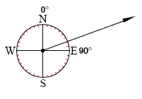
Megan's bearing is written as North70°East (N 70°E).
Note that a straight line has two bearings. For example, the line above can be extended down into the SW quadrant.
Example 2 - Jake is walking on the line in the sketch going southerly. What is his bearing?
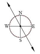
Step 1. State the primary direction. In this case, the primary direction is south.
Step 2. Count the degrees from the primary direction. Counting from south, the angle is 30.°
Step 3. State the direction the angle is deflected. The angle is deflected to the East.
Jake's bearing is written as South30°East (S 30°E).
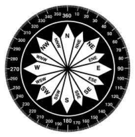
6.2 Azimuths
6.2 Azimuths Anonymous (not verified)An azimuth is the direction measured in degrees clockwise from north on an azimuth circle. An azimuth circle consists of 360 degrees. Ninety degrees corresponds to east, 180 degrees is south, 270 degrees is west, and 360 degrees and 0 degrees mark north.
The word "bearing" is sometimes used interchangeably with azimuth to mean the direction (the degree reading) from one object to another. As shown in Section 6.1, this usage is correct only in the first (NE) quadrant between 0° and 90°.
Example 1 - What is the bearing and azimuth reading of the line?
The azimuth reading is 45° or the bearing is N 45° E.
Notice that in this case the azimuth and bearing are both the same because the direction is in the NE or first quadrant.
Azimuths can also be read from the south. In the previous example, the azimuth reading is 225° from the south. The National Geodetic Survey of the National Oceanic and Atmospheric Administration (NOAA) (formerly the United States Coast and Geodetic Survey) always uses south as the zero direction. In wildland fire service, the azimuth is always read from the north point.
WIND DIRECTION
Azimuth is often used to denote wind direction. Traditionally, wind direction is reported as one of eight compass point (N, NE, E, SE, S, SW, W, NW). However, plots of wind and speed direction often give an azimuth value using 0° and 360° for north, as described above. Winds are named according to the direction from which they are blowing. For instance, a westerly wind blows from the west (or 270°), while a southeasterly wind blows from the southeast (135°).
6.3 Back Azimuth and Backsighting
6.3 Back Azimuth and Backsighting Anonymous (not verified)A back azimuth is a projection of the azimuth from the origin to the opposite side of the azimuth circle. There are 360 degrees in the azimuth circle, so the opposite direction would be 180 degrees (half of 360 degrees) from the azimuth.
A back azimuth is calculated by adding 180° to the azimuth when the azimuth is less than 180°, or by subtracting 180° from the azimuth if it is more than 180°. For example, if an azimuth is 320°, the back azimuth would be 320° - 180° = 140°. If the azimuth is 30°, the back azimuth would be 180° + 30° = 210°.
Backsighting is a method of sighting that uses an azimuth reading taken backwards. Backsighting uses the azimuth sight and turns it around to find the way back to the original starting point.
Example 1 - Susan is at the lookout point and sights a fire at 100°. She starts out in the direction of the fire, but soon loses sight of the fire. Susan turns around and backsights to the lookout point. It is 260°. How many degrees off course is she? Which direction does Susan need to move to get back on course?
Step 1. The azimuth, 260°, is more than 180°, so subtract 180° from the azimuth. 260° 180°= 80°
Step 2. Subtract the calculated backsight reading from the original azimuth reading.
100° - 80° = 20°
Susan is 20 degrees off course.
Because the new azimuth (80°) is less than the original (100°), Susan needs to move to the left to make the back azimuth larger by 20°. When the lookout line of sight back azimuth of 280° is read, she can proceed along the line toward the fire.
Susan needs to move to the left by 20 degrees.
6.4 Compass
6.4 Compass Anonymous (not verified)A compass is an instrument used to determine direction in fire control work. An azimuth compass is graduated/marked with a full circle of 360 degrees called an azimuth circle. Compass components include a magnetic needle that always points to magnetic north, a graduated circle for laying off angles from true north, and a sighting line for extending a line of sight while following a course of direction. The north end of the needle is marked with a small arrow.
READING THE COMPASS AND SIGHTING
1. Always hold the compass level and firmly against the body to keep it still.
2. Determine which direction is north by moving to get the north needle to the correct position, magnetic north.
3. To determine the direction of an object, hold the compass and align the direction of the travel arrow with the object.
4. Read the azimuth where the index line meets the 360°dial. Look along the sighting line and then, by raising the eyes, extend the line of sight.
5. Take note of one or more objects, such as a tree or a rock, along the line of sight. Walk to the most distant object noted along the line of sight, and take another sight with the compass.
The compass direction can also be read off a map, by drawing a straight line between the initial point and the point of destination. Place the compass on the map so the orienting lines on the 360° dial point to north on the map. Read the compass on the map.
6.5 Declination
6.5 Declination Anonymous (not verified)The magnetic reference for Earth is north regardless of whether you are traveling north or south. Magnetic declination, or declination, is the difference between the true north reading from the map and the magnetic north reading from a compass. When a compass is used in combination with a map, a correction must be made to allow for declination.
In North America, magnetic declination varies from 30 degrees East in Alaska to 20 degrees West in Labrador, Maine. The degrees of declination for an area are usually located on the bottom margin of the map near the north arrow, or they can be located using a declination chart.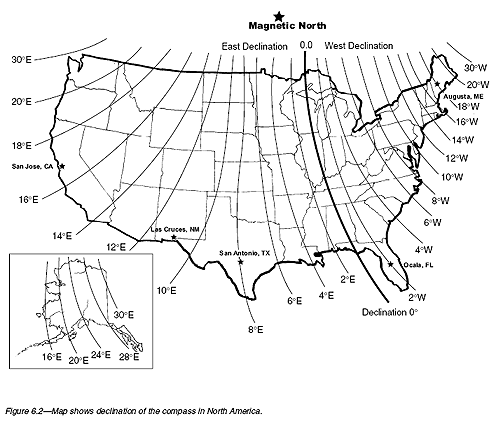
The method for correcting for declination is as follows:
1. For Easterly Declination, subtract the declination from the true reading to obtain the magnetic reading. Magnetic = true - easterly declination
2. For Westerly Declination, add the declination to the true reading to obtain the magnetic reading. Magnetic = true + westerly declination
An easy way to remember whether to add or subtract is "West is best and East is least." So for West declination, add to the true reading (West is best, and therefore a larger number) and for East declination subtract from the true reading (East is least, and therefore a smaller number).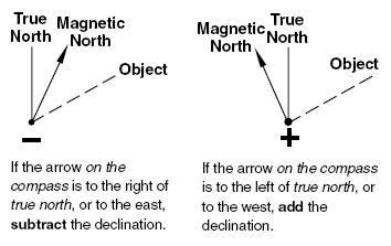
Example 1 - Paloma is in San Jose, California. The declination is 17°E. Paloma's compass reading from her current location to the mountain range to which she is traveling is 35°. What is her true reading?
Step 1. The declination of 17°E is an easterly declination.
Step 2. In this case, True - east = magnetic according to the "East is least" guideline above, so we will solve the equation for the true reading and find that true = magnetic + east. We must add the declination to go from the magnetic reading on the compass to the true reading.
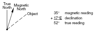
Paloma's true reading is 52 degrees.
Example 2 - Sonia is in Augusta, Maine. She has a compass with a magnetic north reading of 45°. What is her true reading on a map?
Step 1. Look up the declination for Augusta, Maine, on a declination chart. Maine has a declination of 18°W.
Step 2. Because 18°W is a westerly declination, remember "West is best" and that the magnetic = true + west. In this case, to solve for the true reading, we must subtract the declination from the magnetic bearing: true = magnetic - west.
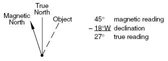
Sonia's true reading is 27 degrees.
When traveling in an opposite direction and adjusting map readings for use with compass readings, do the opposite of the above for adding and subtracting the declination.
Example 3 - Roger looks at a map and takes an azimuth reading of 85°, a true reading, off the map from where he is standing to the location of a tower. The declination for the area is 12°E. What is the magnetic reading?
Step 1. In order to find the magnetic reading by using a compass, subtract the easterly declination. Remember, "East is least."
85° - 12°= 73°
Roger's magnetic reading is 73 degrees.
6.6 Vectors
6.6 Vectors Anonymous (not verified)A vector has a magnitude (often representing distance or speed) and direction. When a clinometer (see Section 4.5) is used to estimate the slope percent and the slope length is measured with a metal tape, the result is a vector. The slope length represent the magnitude and the slope percent can be converted into a slope angle that represents direction. Vectors can provide information about the distance and direction of fire spread, or the speed and direction of fire spread or wind.
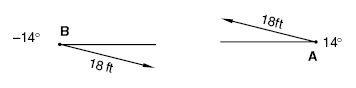
Example 1 - Linda is standing at point A. John is standing at point B. John reads the clinometer and finds a slope percent of 25 percent. They measure the slope length and get 18 feet. Draw the vector from point A and then again from point B.
Step 1. Following the steps in Section 4.5, convert the 25 percent to an angle with a calculator using inverse tan (tan-1).
tan A = 0.25, angle A = 14°
Step 2. Draw the vectors.
WIND VECTORS
Wind is the horizontal movement of air relative to the surface of Earth. Recall from Section 6.2 that the wind direction is named by the direction from which the wind is blowing. If the wind is northerly, then the wind is coming from the north. When the wind is blowing into your face, the wind would be named from the direction you are facing. For example, Mandy is facing south and the wind is blowing into her face. The wind is said to be a southerly wind.
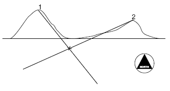
6.8 Intersection
6.8 Intersection Anonymous (not verified)Intersection is a method of locating a point on a map by intersecting lines from two known landmarks on the ground. Intersection is one method fire lookouts use in determining the location of a fire. The procedure is as follows:
- From the first position, point 1, take a compass reading of the object or fire.
- Adjust for declination.
- With a compass or protractor, plot this azimuth on the map.
- Draw a line from point 1 beyond the point of the object or fire.
- Move down the road to a second position, or radio to the second person's location and get that azimuth reading. Repeat steps 2 through 4.
- A third and maybe a fourth reading will help further describe the location.
- The object or fire is located where the individual lines cross.
Example 1 - Tom is at a lookout tower at point A. He spots a fire and takes a compass reading. The magnetic azimuth is 277°. He radios to John at tower B, who tells him his magnetic azimuth on the fire is 337°. The declination for the area is 16°E. Plot the lines to find the location of the fire.
Step 1. Convert the magnetic azimuths to true azimuths by adjusting for declination (see Section 6.5).
277° + 16° = 293°
337°+ 16°= 353°
Step 2. Draw the lines of the azimuth from each point well past the fire.
Step 3. Read where the two lines intersect to get the location of the fire.
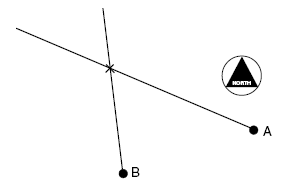
6.9 Resection
6.9 Resection Anonymous (not verified)Resection is a method of finding one's own location on a map by sighting two known landmarks.
The procedure is as follows:
- Find at least two landmarks on the map that can be also identified on the ground. With a compass measure an azimuth to each of the landmarks on the ground.
- Adjust for declination.
- Convert to back azimuths.
- Using the two known landmarks on the map, draw the lines of the back azimuths until the lines cross.
- The location is where the two lines cross.
Example 1 - Mario is in the woods and is unsure of his current location. He sees two peaks in the distance and locates them on his map. He takes the azimuth reading of the first peak and gets 327°
. He takes a reading for the second peak and gets an azimuth reading of 83°. The declination for the area is 17°W. Find Mario's location on the map below.
Step 1. Convert the magnetic azimuths to true azimuths (see Section 6.5).
327° - 17° = 310°
83° - 17° = 66°
Step 2. Convert to back azimuths.
310° - 180°= 130°
66° + 180°= 246°
Step 3. From the two known landmarks on the map, draw the lines of the back azimuths until the lines intersect.
6.10 Latitude & Longitude
6.10 Latitude & Longitude Anonymous (not verified)Latitude and longitude are measuring lines used for locating places on the surface of the Earth. They are angular measurements, expressed as degrees of a circle. A full circle contains 360°. Each degree can be divided into 60 minutes, and each minute is divided into 60 seconds. The symbol for minutes is (´) and for seconds is (").
Latitude lines (called parallels) circle the planet's surface in lines parallel to the equator, which lies halfway between the North and South poles. Latitude lines circle the planet from east and west, beginning at 0° at the equator and increasing to 90°North or 90°South.
Longitude lines (called meridians) run north and south and circle the planet from pole to pole. Each line is identified by the number of degrees east or west from a starting point at Greenwich, England, known as the prime meridian. The longitude at the prime meridian is 0°. Longitudes lines mark the distance westward, to 180°West, and eastward, to 180°East.
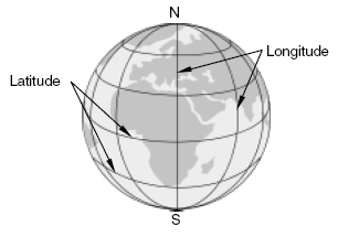
Latitude and longitude measurements can be written in several ways. For example, 211 degrees, 22 minutes, and 30 seconds is written as 211° 22´30", or with spaces: 211 22 30; or with a decimal after the degrees 211.22´30", or with a decimal after the minutes 211 22.30. One degree of latitude equals about 69 miles. One minute is just over a mile, and one second is about 100 feet.
When adding or subtracting degrees, convert to minutes and seconds as necessary and borrow the appropriate amount (see Section 1.3). For example, when borrowing 1 degree from 360°, change to 359°60´. To borrow 1 minute from 359° 60´, change to 359° 59´60".
Example 1 320°25´32" - 210°50´41"

Step1. Subtract 1 from 2.
2 - 1 = 1
Step 2. Borrow 1 minute from the 5 for the seconds.
There are 60 seconds in 1 minute.
60 + 30 = 90
Step 3. Subtract 4 from 9.
9 - 4 = 5
Step 4. Subtract 0 from 4.
4 - 0 = 4
Step 5. Borrow 1 degree from 20° for the minutes. There are 60 minutes in 1 degree.
60 + 20 = 80
Step 6. Subtract 5 from 8.
8 - 5 = 3
Step 7. Subtract 210 from 319.
319 - 210 = 109
109°34´51"
Example 2 - Add 142° 54´ 43" + 85° 36´ 44".

Step 1. Add the seconds. 43 + 44 = 87
Sixty seconds equals 1 minute.
Step 2. 87 is greater than 60, so subtract 60 seconds from 87 seconds. There are 60 seconds in 1 minute, so add 1 minute to the minute column.
87 - 60 = 27 seconds
Step 3. Add the minutes.
54 + 36 + 1 (carried over from the seconds) = 91 minutes
Step 4. 91 is greater than 60, so subtract 60 minutes from 91 minutes. There 60 minutes in 1 degree, so add 1 to the degree column. 91 - 60 = 31 minutes
Step 5. Add the degrees.
142 + 85 + 1 (carried over from the minutes) = 228 degrees
228°31´27"
Example 3 - Name the range of latitude and longitude for the borders of Wyoming.
Step 1. Find Wyoming on a map.
Step 2. Locate the east and west borders of Wyoming.
Longitude 111°W to 104°W. It is west of the Greenwich Longitude.
Step 3. Find the north and south borders of Wyoming.
Latitude 41°N to 45°N. The location is north of the equator.
6.11 Base, Township, Range, Sections, & Corners
6.11 Base, Township, Range, Sections, & Corners Anonymous (not verified)Base and meridian lines are similar to latitude and longitude lines. Use geographic locations, such as prominent features of the area, as reference points.
Townships are rectangular blocks of land about 6 miles square. The squares are gridded and numbered according to their position north or south of the base line.
Ranges are columns of townships set side by side. They are numbered starting at the meridian that runs through the point of origin of each system. Ranges run east and west.
Sections represent further divisions of a township. A township can be divided into 36 sections. Each section is about 1 square mile. Sections are numbered from the top right, or northeast section, then to the left, and down in an "S" formation. The section below is taken from T.2S., R.2E. Any township can be found by identifying the township number, then the range number, and finally the base and meridian system.
Corners describe areas within a section to provide more specific location information. Corners can be described as northeast, southeast, northwest, and southwest. There are corners within corners. For example, the figure below indicates a lightning strike at the point labeled "X" in section 22. The lightning strike is located in the northwest corner of the northwest corner of section 22 of T.2S., R.2E.
The legal description of land begins with the smallest unit and ends with the largest unit. In the case below, the section location is written as T.2S., R.2E., M.D.M., which describes Township 2 South, Range 2
East, Mt. Diablo Meridian.
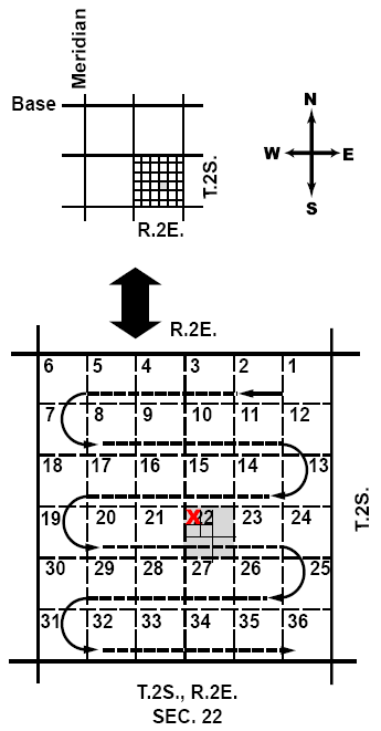
Example 1 - What is the township, range, and section of the lightning strike labeled "X" in the figure?
Step 1. Write the township.
T.2S.
Step 2. Write the range.
R.2E.
Step 3. Write the section.
22
Example 2 - What would you tell the dispatcher is the exact location of the lightning strike using corners?
Step 1. Write the corners.
Northwest corner of the northwest corner
Step 2. Write the section.
22
Step 3. Write the township and range.
T.2S., R.2E.
NW corner of the NW corner, Section 22, T.2S., R.2E.