6.8 Intersection
6.8 Intersection Anonymous (not verified)Intersection is a method of locating a point on a map by intersecting lines from two known landmarks on the ground. Intersection is one method fire lookouts use in determining the location of a fire. The procedure is as follows:
- From the first position, point 1, take a compass reading of the object or fire.
- Adjust for declination.
- With a compass or protractor, plot this azimuth on the map.
- Draw a line from point 1 beyond the point of the object or fire.
- Move down the road to a second position, or radio to the second person's location and get that azimuth reading. Repeat steps 2 through 4.
- A third and maybe a fourth reading will help further describe the location.
- The object or fire is located where the individual lines cross.
Example 1 - Tom is at a lookout tower at point A. He spots a fire and takes a compass reading. The magnetic azimuth is 277°. He radios to John at tower B, who tells him his magnetic azimuth on the fire is 337°. The declination for the area is 16°E. Plot the lines to find the location of the fire.
Step 1. Convert the magnetic azimuths to true azimuths by adjusting for declination (see Section 6.5).
277° + 16° = 293°
337°+ 16°= 353°
Step 2. Draw the lines of the azimuth from each point well past the fire.
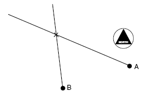
Step 3. Read where the two lines intersect to get the location of the fire.