6.9 Resection
6.9 Resection Anonymous (not verified)Resection is a method of finding one's own location on a map by sighting two known landmarks.
The procedure is as follows:
- Find at least two landmarks on the map that can be also identified on the ground. With a compass measure an azimuth to each of the landmarks on the ground.
- Adjust for declination.
- Convert to back azimuths.
- Using the two known landmarks on the map, draw the lines of the back azimuths until the lines cross.
- The location is where the two lines cross.
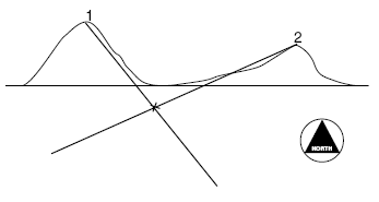
Example 1 - Mario is in the woods and is unsure of his current location. He sees two peaks in the distance and locates them on his map. He takes the azimuth reading of the first peak and gets 327°
. He takes a reading for the second peak and gets an azimuth reading of 83°. The declination for the area is 17°W. Find Mario's location on the map below.
Step 1. Convert the magnetic azimuths to true azimuths (see Section 6.5).
327° - 17° = 310°
83° - 17° = 66°
Step 2. Convert to back azimuths.
310° - 180°= 130°
66° + 180°= 246°
Step 3. From the two known landmarks on the map, draw the lines of the back azimuths until the lines intersect.